Geographical Features !
Rotourua Geothermal.

~ Geysers, Mud Pools and Thermal Springs have been attracting visitors to Rotorua since the 1800's.
~ Natural forces: A geothermal field is created with the presence of water, heat and fast access to the earths surface for geothermal water. Cold rainwater then seeps through the cracks in rocks towards a geothermal heat source, heatings as it descends in further. It then rises quickly to the surface as geysers, fumaroles and hot springs.
~ Here, warriors would bathe in the sulphurous waters to heal their wounds after battle and remove the “tapu” (sacredness) of war.
~ The Rotorua geothermal field contains over 1200 geothermal features
Lake Taupo.

~ Lake Taupo has a surface Area of 616 Square Kilometres (238 sq mi), it is the largest lake by surface area in New Zealand's North Island.
~ Lake Taupo lies in a caldera created by a super-volcanic eruption which occurred approximately 26,500 years ago. According to geological records, the volcano has erupted 28 times in the last 27,000 years
~ Maori rock carvings at Mine Bay on Lake Taupo are over 10 meters high, and are only accessible by boat or Kayak.
~ There are many things to do on or by Lake Taupo, however, most activities have a slight fee to join in the fun.
South Alps.
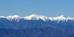
~ The southern Alps is a mountain range that extends along most of New Zealand's South Island, it reaches its greatest elevations near the western side of the South Island.
~ When people talk about the 'Southern Alps' they are generally referring to the entire range around the South Island, however, there are many smaller ranges that form the 'Southern Alps' and these have their own separate names.
~ There is wildlife living in the mountains, these include things like the endemic Rock Wren and the Kea (a large parrot that was once hunted as a pest). There is also a number of insects that have adapted to the high altitudes, these are things like flies, moths, beetles, and bees. The beach forests of the lower elevations are an important habitat to two native birds; the Kaka and Kiwi
Milford Sound.
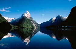
~ Milford Sound is a deep, icy blue waterway running 15km inland from the Tasman Sea and is part of the majestic Fiordland National Park.
~ Carved over time by glaciers, the deepest part of the fiord is 400m, surrounded by sheer rock faces rising 1,200m or more on either side. Milford Sound is the wettest inhabited place in New Zealand and one of the wettest in the world, with a mean annual rainfall of close to 7m, feeding the many waterfalls that thunder down cliff faces.
~ Visitors attracted by the spectacular waterfalls gushing from rock faces rising 1,200 meters and more from the sea, as well as luscious rain forests clinging to the cliffs, and the seals, penguins and dolphins that live in the waters.
Waikato River.
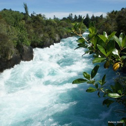
~ The Waikato River is New Zealand's longest river, it runs for 425 kilometers through the North Island.
~ What remains of the old river path can still be seen clearly at Hinuera, where the cliffs mark the ancient river edges. ~ Waikato Rivers main tributary is the Waipa River, which merges with tthe Waikato at Ngaruawahia.
~ What remains of the old river path can still be seen clearly at Hinuera, where the cliffs mark the ancient river edges. ~ Waikato Rivers main tributary is the Waipa River, which merges with tthe Waikato at Ngaruawahia.
Bay of Islands.
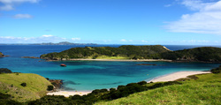
~ Bay of Island is an area in the North Region in New Zealands North Island. It is located 60km North-West of Whangerei, its close to the northern tip of the country.
~ The Bay itself is asymmetraical with a 16km wide inlet in the North-Eastern part of the Island. It has several arms which extend into the land.
~ The Bay of Islands is one of the most popular places for fishing, sailing and destination for tourists, in the country.
~ The Bay itself is asymmetraical with a 16km wide inlet in the North-Eastern part of the Island. It has several arms which extend into the land.
~ The Bay of Islands is one of the most popular places for fishing, sailing and destination for tourists, in the country.
